How Did the Berlin Conference Divide Africa?
How the 1884–1885 Berlin Conference established rules for European conquest, accelerated Africa’s partition and excluded every African polity.
Short answer
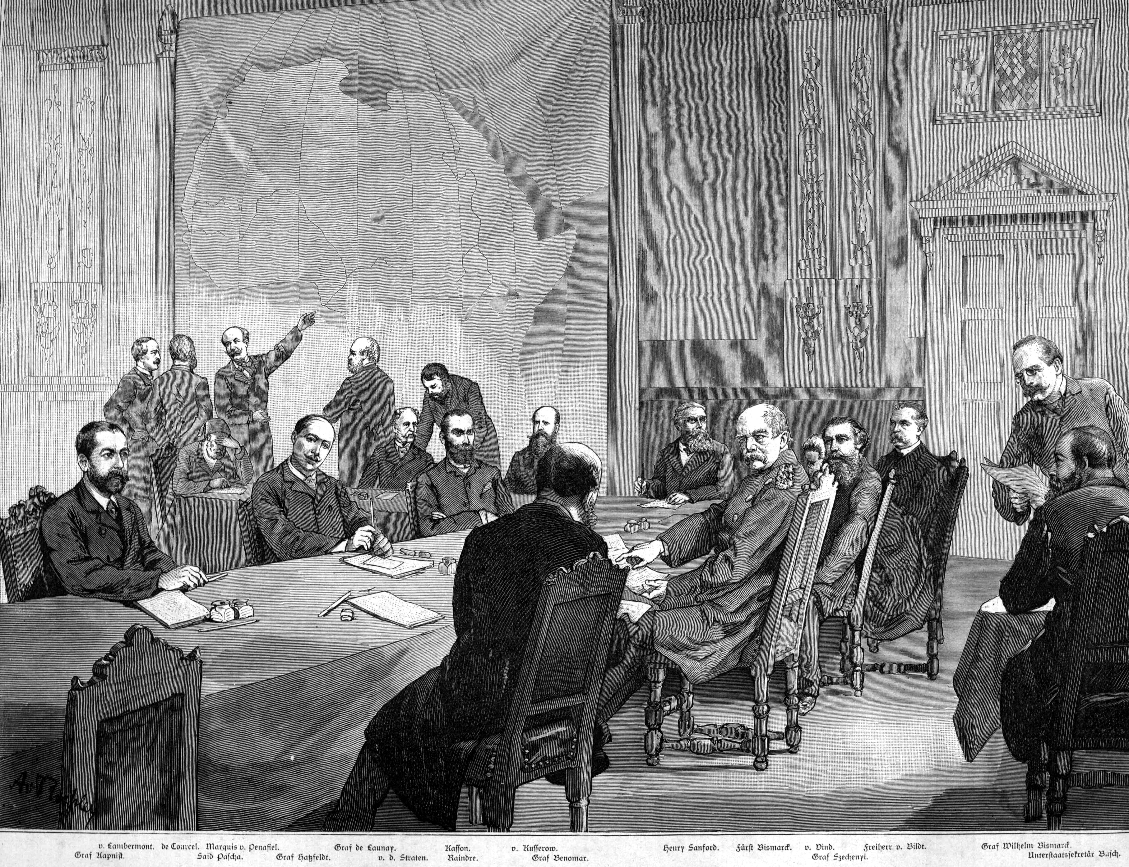
Fourteen states met in Berlin in 1884–1885, but no African representative attended. The conference did not draw all of Africa’s eventual borders on one map. Instead, it established rules through which European powers could claim territory, secure international recognition and suppress African sovereignty. Those rules accelerated the Scramble for Africa: European control rose from roughly 10% in 1870 to about 90% by 1914.
Key takeaways
- Fourteen states met in Berlin in 1884–1885, while no African government or community received representation.
- The conference did not draw every border; it established rules that legitimised and accelerated European occupation.
- European control expanded from roughly 10% of Africa in 1870 to about 90% by 1914.
- The General Act protected commerce and navigation while colonial armies imposed conquest, taxation, forced labor and extraction.
- Most colonial borders survived independence after the Organisation of African Unity adopted territorial continuity in 1964.
The short answer: rules for conquest, not one master map
German chancellor Otto von Bismarck convened representatives of 14 states in Berlin on 15 November 1884. The conference ended on 26 February 1885, when its participants signed the General Act of Berlin. Belgium’s King Leopold II had pressed for international acceptance of his ambitions in the Congo Basin. No African ruler, state or political community was represented.
The delegates did not divide the entire continent into finished colonies at the conference table. They created diplomatic and legal procedures that made division easier: free trade in the Congo Basin, freedom of navigation on the Congo and Niger rivers, notification of new coastal claims, and proof of authority sufficient to protect trade and existing rights. This last principle became known as effective occupation.
“Any Power which henceforth takes possession of a tract of land on the coasts of the African Continent… shall accompany the respective act with a notification thereof.” — General Act of the Berlin Conference, Article 34, 1885.
That framework turned occupation into a competitive requirement. European governments negotiated boundaries with one another, dispatched armies and administrators, imposed treaties, and demanded taxes or labor from African societies. Explore the broader histories of colonial empires and their place in global history.
What the General Act established
The General Act contained 38 articles in 1885. Its principal measures declared commercial access across the conventional Congo Basin, protected navigation on the Congo and Niger systems, established notification procedures for coastal annexations and required an occupying power to maintain authority in a claimed area. The conference also recognised Leopold’s International Association of the Congo; the separate Congo Free State was publicly constituted under his personal sovereignty in 1885.
The Act’s language opposed the slave trade and spoke of protecting Indigenous populations. In practice, those declarations did not prevent forced labor, hostage-taking, punitive expeditions or mass killing. Leopold’s Congo regime compelled communities to collect rubber and other commodities. Historian Adam Hochschild estimated in 1998 that the population loss between 1880 and 1920 was approximately 10 million, while demographers and historians stress that the absence of a reliable precolonial census makes any single total uncertain. The loss combined killing, famine, disease and falling births.
Berlin’s central consequence was not geometric border-making in one room, but the conversion of European assertions into claims that rival European governments agreed to recognise.
The rules favored states able to deploy capital, soldiers, gunboats and administrators. African treaties were often obtained under coercion, mistranslated or treated as outright transfers of sovereignty when African signatories understood them as agreements of friendship or limited access. This machinery belongs within the archive’s wider account of empire and extraction.
How rapidly European control expanded
Measures vary because historians distinguish formal annexation, effective administration, spheres of influence and areas only nominally claimed. A widely used textbook summary places European control at about 10% in 1870 and nearly 90% in 1914. By 1914, only Ethiopia and Liberia remained internationally recognised as independent African states, although Liberia was heavily constrained by foreign finance and Ethiopia faced continuing imperial pressure.
The acceleration was enforced through wars rather than achieved by paperwork alone. Britain occupied Egypt in 1882 and conquered the Sokoto Caliphate in 1903. France captured Samori Touré in 1898 after prolonged resistance. German forces committed genocide against the Ovaherero and Nama between 1904 and 1908: a German government statement issued in 2015 described the campaign as genocide, while historians commonly cite about 65,000 Ovaherero and 10,000 Nama deaths. Italy was defeated by Ethiopia at Adwa in 1896, demonstrating that European conquest was neither automatic nor uncontested.
Estimates, boundaries and disputed interpretations
There is no defensible count of “countries divided at Berlin,” because the conference recognised procedures and selected claims rather than assigning every later colony. Nor is there one uncontested percentage for European possession in 1884–1885. The comparison below separates measurable facts from historical shorthand.
| Measure or interpretation | Figure and date | Source or qualification |
|---|---|---|
| Participating states | 14, 1884–1885 | General Act signatories and conference record |
| African representatives | 0, 1884–1885 | No African polity received representation |
| European-controlled territory | About 10%, 1870 | Common synthesis used by historians including H. L. Wesseling; definitions vary |
| European-controlled territory | About 90%, 1914 | Common synthesis; includes colonies and protectorates |
| Independent recognised states | 2, 1914 | Ethiopia and Liberia, with important limits on Liberia’s autonomy |
| African borders following geographic features | About 26%, calculated in 2006 | Alesina, Easterly and Matuszeski’s quantitative border study |
| African borders consisting of straight lines | About 44%, calculated in 2006 | Same study; measurement depends on coding rules |
Some popular accounts say Europeans “drew Africa’s borders at Berlin.” Historians dispute that literal formulation because many boundaries were fixed afterward: the Anglo-German agreement of 1890, for example, rearranged claims in eastern and southwestern Africa. Others warn that emphasizing this correction can obscure Berlin’s importance. The conference formalized a system in which Europeans adjudicated African sovereignty among themselves.
The familiar claim that straight lines prove arbitrary partition also requires care. Alesina, Easterly and Matuszeski calculated in 2006 that approximately 44% of African borders were straight lines and about 26% followed geographic features. Yet even rivers or watersheds could sever political, linguistic and economic networks. Geometry alone does not measure violence or illegitimacy.
What followed from the partition
Partition placed communities under administrations designed chiefly for strategic control, taxation and extraction. Colonial borders split Somali, Ewe, Bakongo, Maasai and many other populations, while forcing rival or politically distinct societies into common colonial units. Administrators frequently hardened flexible identities into official ethnic categories and governed through selected intermediaries.
The economic consequences differed by colony but shared a coercive structure: land seizure, concessionary companies, hut or poll taxes, compulsory crop production and forced labor redirected African economies toward European demand. Railways commonly connected mines or plantations to ports rather than building integrated domestic markets. See the archive’s history of colonial rule and comparative guide to European empires.
Most present-day African interstate boundaries descend from colonial lines because the Organisation of African Unity resolved in 1964 to respect borders existing at independence. Its members feared that wholesale revision would generate further wars. That decision did not validate the original conquests; it was a postcolonial strategy for limiting conflict within a territorial order imposed without African consent.
Berlin therefore matters as an institutional turning point. It supplied common rules, reduced the risk of war among colonizing powers and transferred that violence onto African societies. Its legacy lies not in a single legendary map, but in the rapid conversion of commercial ambitions and coastal footholds into territorial empires.
Sources & further reading
- General Act of the Berlin Conference, 1885 — German History in Documents and Images
- Encyclopaedia Britannica: Berlin West Africa Conference
- H. L. Wesseling, Divide and Rule: The Partition of Africa, 1880–1914 — WorldCat
- Alesina, Easterly and Matuszeski, “Artificial States” — NBER, 2006
- United States Holocaust Memorial Museum: Herero and Nama Genocide
- Organisation of African Unity, Cairo Resolution on Border Disputes, 1964 — African Union
Frequently asked questions
- Did the Berlin Conference draw Africa’s borders?
- Not as a complete continental map. Between 15 November 1884 and 26 February 1885, delegates established rules for notifying claims and demonstrating effective occupation. European governments later fixed many borders through bilateral treaties, military conquest and administrative decisions, including the Anglo-German agreement of 1890.
- Which countries attended the Berlin Conference?
- Fourteen states attended in 1884–1885: Austria-Hungary, Belgium, Denmark, France, Germany, Italy, the Netherlands, the Ottoman Empire, Portugal, Russia, Spain, Sweden–Norway, the United Kingdom and the United States. No African state or ruler was represented; the United States signed the General Act but did not ratify it.
- What was effective occupation?
- Effective occupation was the requirement, articulated for new African coastal possessions in Articles 34 and 35 of the 1885 General Act, that a claimant notify other powers and establish sufficient authority to protect rights and trade. It encouraged European governments to replace paper claims with soldiers, treaties, tax systems and colonial administrations.
- How much of Africa was colonized after the Berlin Conference?
- A commonly cited historical synthesis estimates European control at about 10% of African territory in 1870 and nearly 90% by 1914. Exact shares vary according to whether nominal claims, protectorates or effective administration are counted. In 1914, Ethiopia and Liberia were the only internationally recognised independent African states.
- Why is the Berlin Conference still important?
- The 1884–1885 conference made European governments the arbiters of claims to African territory while excluding Africans. Its framework accelerated conquest, extraction and border-making. Most resulting boundaries remained after independence because the Organisation of African Unity resolved in 1964 to respect inherited borders, seeking to prevent territorial wars rather than endorse colonial rule.
Related chapters
Questions
- Did Britain Cause the Bengal Famine of 1943?
- Did France Use Torture in Algeria?
- How Did the Dutch VOC Rule Indonesia?
- How Does Debt Keep Former Colonies Poor?
- How Is Racism Structured in the Present Day?
- How Many Indigenous People Died in the Americas After 1492?
- How Many People Died in the Congo Free State?
- How Many People Were Taken in the Atlantic Slave Trade?
- How Much Wealth Did Britain Extract from India?
Sources & further reading
CC BY 4.0 ·